


Understanding the Most Populated ZIP Codes in the United States offers a unique lens into how Americans live, migrate, and build communities. ZIP codes aren't just mailing tools, they reflect housing trends, suburban expansion, and regional economic growth across the United States. This blog post breaks down the largest ZIP codes by population, highlights geographic patterns, and explains the forces behind extreme growth.
Largest ZIP Codes in America - Key Findings
- The most populated ZIP codes are concentrated in Texas, New York, and California.
- Several suburban ZIP codes now rival mid-sized cities in population.
- High housing availability strongly correlates with ZIP code growth.
- Gender distribution across the largest ZIP codes remains relatively balanced.
Top 25 Most Populated ZIP Codes in the United States
Below is a snapshot of the 25 ZIP codes with the largest resident populations, including housing units and gender distribution.
| ZIP Code | City | County | Population | Housing Units | Male | Female |
|---|---|---|---|---|---|---|
| 08701 | Lakewood | Oconto | 135,256 | 34,750 | 66,792 | 67,216 |
| 77494 | Katy | Harris | 130,872 | 42,612 | 64,479 | 66,441 |
| 77449 | Katy | Harris | 128,180 | 40,123 | 59,558 | 62,540 |
| 11368 | Corona | Roberts | 117,110 | 33,678 | 59,755 | 52,995 |
| 60629 | Chicago | Cook | 114,453 | 35,263 | 53,890 | 55,107 |
| 78660 | Pflugerville | Travis | 110,955 | 40,688 | 56,495 | 56,891 |
| 77084 | Houston | Harris | 109,808 | 39,314 | 51,052 | 57,505 |
| 77433 | Cypress | Harris | 106,663 | 34,046 | 54,627 | 53,260 |
| 11220 | Brooklyn | Green | 105,797 | 33,274 | 46,378 | 46,630 |
| 11373 | Elmhurst | Lackawanna | 105,712 | 35,036 | 51,163 | 51,455 |
| 79936 | El Paso | El Paso | 105,150 | 37,845 | 52,867 | 54,645 |
| 10467 | Bronx | Bronx | 103,660 | 39,582 | 46,807 | 51,906 |
| 11219 | Brooklyn | Green | 103,447 | 30,455 | 47,258 | 45,025 |
| 90650 | Norwalk | Monroe | 102,891 | 28,456 | 51,407 | 50,576 |
| 90011 | Los Angeles | Los Angeles | 102,308 | 24,348 | 54,439 | 51,603 |
| 11208 | Brooklyn | Green | 101,958 | 34,315 | 51,983 | 56,197 |
| 11226 | Brooklyn | Green | 101,727 | 40,596 | 46,615 | 54,438 |
| 11385 | Ridgewood | Queens | 100,883 | 39,275 | 52,354 | 53,167 |
| 91331 | Pacoima | Los Angeles | 100,720 | 23,996 | 51,123 | 48,681 |
| 11236 | Brooklyn | Green | 100,687 | 35,096 | 45,553 | 54,529 |
| 92336 | Fontana | Walworth | 100,594 | 26,596 | 50,277 | 50,294 |
| 94565 | Pittsburg | Camp | 100,341 | 31,128 | 50,722 | 50,104 |
| 11207 | Brooklyn | Green | 100,330 | 37,399 | 43,296 | 53,505 |
| 90250 | Hawthorne | Douglas | 97,653 | 34,677 | 46,977 | 49,223 |
| 92335 | Fontana | Walworth | 96,605 | 25,195 | 48,890 | 47,814 |
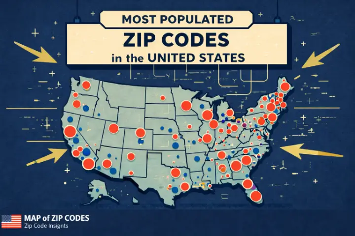
Map of the Most Populated ZIP Codes in America
A geographic view clearly shows clustering in major metro areas, especially around New York City, Houston, and Los Angeles.
Where Are America's Largest ZIP Codes Located?
New York
Dense urban neighborhoods, particularly in Brooklyn, Queens, and the Bronx, drive extremely high population counts within compact ZIP code boundaries.
Texas
Texas dominates the list due to massive suburban ZIP codes around Houston, Austin, and Dallas, where land availability allows for continuous housing development.
California
Southern California ZIP codes combine high density with large immigrant communities and multi-family housing, especially in Los Angeles County.
Why Some ZIP Codes Have Extremely Large Populations
Suburban Growth Is Driving ZIP Code Expansion. Suburbs are no longer small. Master-planned communities, improved transportation, and remote work have enabled ZIP codes to grow to city-scale populations. These areas often feature:
- Large housing inventories
- Family-friendly infrastructure
- Proximity to major job centers
The Largest ZIP Code in Each State
Here are the most populated ZIP codes by state, showing how population leadership varies nationwide.
| ZIP Code | Population | State |
|---|---|---|
| 08701 | 135,256 | NJ |
| 77494 | 130,872 | TX |
| 11368 | 117,110 | NY |
| 60629 | 114,453 | IL |
| 90650 | 102,891 | CA |
| 37013 | 96,379 | TN |
| 30044 | 94,774 | GA |
| 34787 | 88,636 | FL |
| 99301 | 85,272 | WA |
| 73099 | 83,213 | OK |
| 22193 | 83,064 | VA |
| 28269 | 82,422 | NC |
| 96706 | 80,299 | HI |
| 87121 | 77,802 | NM |
| 66062 | 77,553 | KS |
| 84043 | 76,954 | UT |
| 80134 | 76,369 | CO |
| 63376 | 76,064 | MO |
| 89110 | 73,954 | NV |
| 97229 | 73,602 | OR |
| 45011 | 73,596 | OH |
| 47906 | 73,579 | IN |
| 85225 | 73,551 | AZ |
| 20906 | 71,641 | MD |
| 20002 | 69,422 | DC |
| 02301 | 69,418 | MA |
| 06902 | 69,192 | CT |
| 19124 | 68,766 | PA |
| 48197 | 67,895 | MI |
| 29072 | 65,060 | SC |
| 42101 | 64,444 | KY |
| 19720 | 61,043 | DE |
| 83301 | 60,789 | ID |
| 72764 | 60,786 | AR |
| 55044 | 60,446 | MN |
| 70726 | 59,586 | LA |
| 53215 | 59,359 | WI |
| 59901 | 57,900 | MT |
| 35242 | 57,008 | AL |
| 38654 | 56,730 | MS |
| 58104 | 48,150 | ND |
| 02860 | 47,894 | RI |
| 57106 | 47,877 | SD |
| 68516 | 47,448 | NE |
| 04401 | 44,608 | ME |
| 50613 | 43,667 | IA |
| 99504 | 42,375 | AK |
| 26554 | 42,133 | WV |
| 03103 | 38,039 | NH |
| 82001 | 37,528 | WY |
| 05401 | 32,059 | VT |
Fastest Growing High-Population ZIP Codes
ZIP codes in Texas, Arizona, and Florida show the fastest year-over-year growth due to job creation, lower housing costs, and inbound migration from coastal states.Methodology
Data Sources
Population and housing data were compiled from recent U.S. Census Bureau estimates and aggregated ZIP-level demographic datasets. For additional demographic context, see https://www.census.gov.
Ranking Criteria
ZIP codes were ranked strictly by total resident population.
ZIP Codes Excluded From the Study
- PO-box-only ZIP codes
- Military-only ZIP codes
- Non-residential or industrial ZIP codes
Frequently Asked Questions
1. What is the most populated ZIP code in the United States?
ZIP code 08701 in Lakewood, New Jersey, ranks first with over 135,000 residents.
2. Why do Texas ZIP codes dominate the list?
Large land areas, rapid suburban development, and strong job markets fuel population growth.
3. Are ZIP codes the same as cities?
No. A single ZIP code can cover parts of multiple cities or just one neighborhood.
4. Do large ZIP codes mean high density?
Not always. Some are geographically large suburbs, others are dense urban areas.
5. How often is ZIP code population data updated?
Typically annually, based on census estimates and surveys.
6. Can ZIP code boundaries change?
Yes. USPS may adjust boundaries as populations and delivery needs change.
Explore More ZIP Code Data
- ZIP Code Boundary Maps for analysis and planning
- Historical population trends by ZIP code
- Housing density and growth forecasts
Download the Full Dataset
A complete downloadable dataset is available for researchers, planners, and analysts who need ZIP-level population insights.