


Bespoke RV & Holiday Park Map Design | Custom Caravan Park Maps
Having crafted over 200 maps of holiday parks, trailer parks, RV parks, and campgrounds worldwide, we are well-versed in presenting varied terrains, from the Australian outback to the vast, rolling hills of Scotland. Our maps offer a clear, comprehensive guide to your park, transforming complex layouts into user-friendly designs.
We understand the challenges faced by larger parks in helping customers navigate to their designated pitch. Imagine the time saved with a high-quality, easily understood map guiding your guests straight to their pitch and showcasing every amenity your park offers.
Our dedicated team of designers work closely with you over several days, ensuring an accurate and aesthetically pleasing representation of your park. We bring your park's most attractive features to life, whether it's a lush golf course, a sprawling sandy seafront, or a serene stream. Your visitors' first impression of your park, either upon arrival or via your website, will be significantly enhanced by our expertly crafted maps.
In today's digital age, the maps we create are more than navigation tools. They are digital assets that reflect the quality and attention to detail that you put into your park. They are adaptable, printable, and most importantly, easily updated as your park evolves. Invest in our meticulously designed maps and see the difference it makes to your visitor's experience.
Please get in touch with us today for an enquiry or for more information.

Our Process to Create Custom Caravan Park Maps

Design requirements and quotations done over email.
1. Quotations and Order Confirmation
We start every RV park, Caravan park, holiday park or Touring park with a long chat. We want to learn as much as possible about your park. We also like to get an idea of your personality and what you’re looking to gain from having a map designed. All of this information will help us design a brilliant looking map that you’ll be proud to show off around your holiday park.
Every quote is custom to every single park. We take a look at how big the park is, how much work will be involved .etc before giving you a quote. This price will include everything from start to finish. We don’t trick you or hide charges at any point during this process.
If you’ve had a park map designed previously then this is the perfect time to send it over. It doesn’t matter if your previous maps are basic, bad or even hand-drawn, every detail will help us get you first proof as accurate as possible.
2. Park Location & Company Research
Our next step is to go away and do even more research on your premises. We will use satellite imagery, planning applications and even customer images/videos to give us as much detail as possible.
Everything we have collected during this process will then be amalgamated into a design document before we start designing.
We consider this step as probably the most important of the whole process. If we can get lots of information on your park then we’ll be able to design your map extremely easily and extremely quickly, while still preserving an incredible amount of accuracy.

Online planning applications are a perfect starting point.
Initial proofs are a perfect representation of the final map.
3. Designing an Initial Proof
Our next job is to start designing the map. As I said previously, we collect all of our research in a design document where we will spend approximately 2 days drawing your park as accurately as possible.
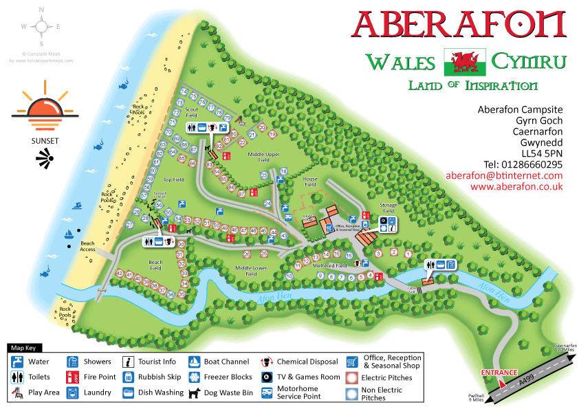
Our designer will begin with the outline of the park. The grass, roads and other concrete areas will be shown before anything else. Pitches and buildings are the next most prominent feature and so will be drawn next. Other natural features like trees, hedges and rivers are then added to the map. Finally, we will add everything that isn’t real. The key, symbols, icons, compass and arrows. All of these things are positioned with personal preference and so can be changed with ease when we receive your amendments.
Once this initial design is complete our designer will save your map as a PDF before moving onto the next step.
4. We Make as Many Amendments as You Need
This is when you first see your map. The PDF we saved in the previous step will be sent over to you and you’ll be asked to come back to us with any changes you want to make. The best way to do this is by printing your map out, scribbling all over it and then sending a scan or image of the map back to us.
Our designers can make the changes you request very quickly, very often on the same day. We will repeat this process of sending you the map, asking for the changes and then amending the map as many times as we need until you’re completely happy with your map.
Unlike a lot of companies, we pride ourselves on not trying to catch you out with hidden charges. We want your map to be exactly how you imagined and we’re happy to go through as many sets of amendments as that takes.
We can amend any aspect of your map.

The final map can be printed and shipped in various formats.
5. Finalization and Map Printing
Once you’re totally happy with your map we can finalize everything and get the map sent over to you in its complete version. Our designers will go over the map one last time, ensuring everything is correct and we haven’t missed anything.
Your map will be saved in various file formats and a compressed ZIP folder will be created. This folder will contain vector versions of your map (.AI, .EPS, .PDF), high-quality image files (.JPG, .PNG) and the original vector file.
At this point we will ask you if you’d like your map printing. We offer printing in practically any size and at any quantity. Some companies like to position large, aluminum signs at the entrance to their park, others like to have their map printed at A4 so they can provide every customer with a beautiful high-quality map to show them around. Please get in touch today if this interests you. You can also visit our printing page to learn more and get an accurate price.
 WIDE ARRAY OF SYMBOLS


