


Editable 3-Digit ZIP Code Maps (AI/EPS/PDF)
Print any size • Highways & cities • Instant download
Commercial use permitted • 1-hour refund • Secure checkout
Download Now - $30Full 5-digit zip code figures and maps for the United States.
Commercial use permitted • 1-hour refund • Secure checkout
Download Now - $30
It's great to have a super detailed map of your desired country showing everything from towns to interstates, road badges and towns but it's potential will quickly run out if you can only use it with everything showing. That's why we've worked hard to categorize and layer everything on these maps. You will need access to a piece of vector editing software but you can easily show and hide layers before exporting as a new file.
This is perfect for those of you who want to show all the roads throughout the United states one day and all the major cities another. Both are perfect quality and can be used easily.
All our file downloads are available in all popular vector file formats: PDF, Adobe Illustrator, SVG, EPS.. Immediately after downloading you can print these maps at ANY size without losing resolution.
The main problem of most US maps on the internet is the lack of detail on everything other than the state and zip code boundaries. We've amalgamated multiple different data sources in order to show: states, state names, 3-digit zip codes, Highways, Interstates, Road Names, Road Badges, Towns and Cities.
All of these layers can be shown and hidden easily. If you want to just show the main roads in a particular state for a presentation that's easily possible.


In order for us to layer the artwork and make it editable after download we needed to produce these maps as vector and by hand.
Every pixel on a regular raster image is either red, green or blue. The problem with this is the fact that, as you zoom in the pixels get bigger and the quality reduces.
Vector graphics, on the other hand are images that are made up from a list of 2D coordinates that produce lines and curves in order to make a design. Every point on a piece of vector artwork has a definite position, no matter the zoom level. This is important because it means you will never lose any quality. You can print a piece of vector artwork at the size of a bus perfectly fine.

Customize the state and colour it's 3-digit zip codes. Create sales territory maps of and every other state using our simple online tool. Add up to 52 headings and color your map according to these headings.
Try For FREE
The 3-digit ZIP Code, a cornerstone of modern postal services, was introduced in 1963 by the United States Postal Service (USPS). This innovation was part of a broader system known as the Zone Improvement Plan (ZIP), aimed at streamlining mail delivery and accommodating the rapid increase in postal demand due to population growth and business expansion. The introduction of ZIP codes marked a significant shift from a manual sorting system to an automated process, vastly improving efficiency.
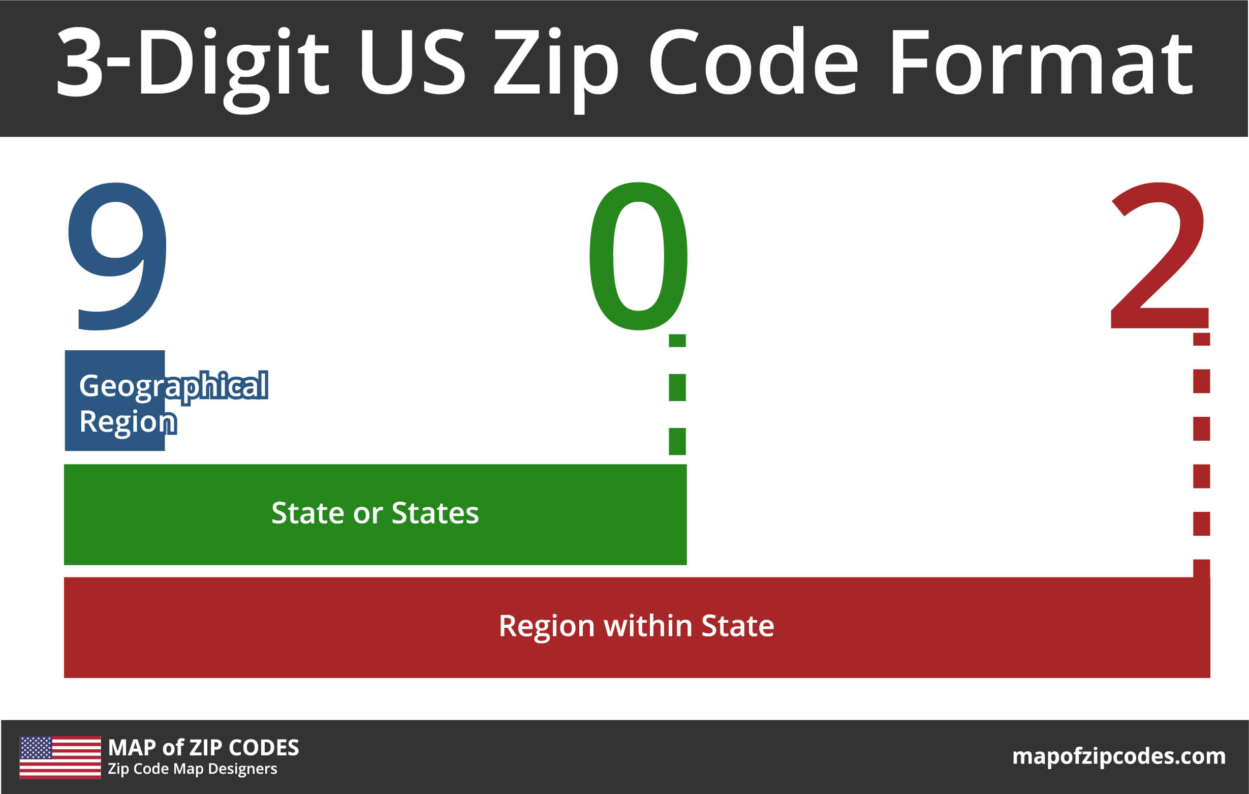
Initially, ZIP codes were five digits, with the first three digits representing the regional processing facility (also known as sectional center facility or SCF) to which the mail would be directed for further processing or delivery. This system allowed the USPS to manage mail more effectively, as the SCF served as a central hub for a set of local post offices. For instance, a ZIP code starting with 123 would indicate a specific area in New York, with the subsequent two digits pinpointing more precise locations like towns or neighborhoods.
The adoption of the 3-digit ZIP Code system facilitated faster sorting and delivery, which was essential in the context of the burgeoning business world and expanding urban areas of the 1960s. It not only revolutionized the way mail was sorted and delivered but also had a lasting impact on areas like marketing, planning, and demographic analysis. Today, 3-digit ZIP codes remain an integral part of the USPS's efficient delivery system and a critical tool for various data analysis and business targeting strategies.
The 3-digit ZIP Code system, an integral part of the postal addressing system in the United States, is designed for efficient mail sorting and delivery. Each 3-digit code corresponds to a particular regional processing facility or Sectional Center Facility (SCF), which acts as a hub for further distribution. This system streamlines the sorting process by quickly categorizing mail based on broad geographic regions.
In the 3-digit ZIP code system, the codes are strategically assigned to cover distinct geographic areas. Each code generally represents a group of U.S. states, a single state, or a part of a large state. This distribution is planned based on factors like population density, transportation routes, and the operational capacity of each SCF. This geographical organization helps in managing the volume of mail and optimizing delivery routes.
Once a piece of mail is tagged with a 3-digit ZIP code, it's routed to the corresponding SCF. Here, further sorting is done based on the full 5-digit ZIP code. The last two digits direct the mail to specific local post offices within the SCF's area. From these local offices, mail is finally dispatched to individual addresses. This hierarchical sorting mechanism ensures mail is efficiently processed from broader regions down to specific localities.
Do anything with your maps from printing to editing and using on a website in 5 simple steps.
The first step is obviously to buy the 3-digit zip code map files. This is very easy to do. Simply click here[] or on any of the red buttons below. On the resulting page simply enter your details, choose your preferred payment method and click by now.
Step 2 is to receive the files. We try to make this as easy as possible by giving you the download links in various places. You can click the download link in the order confirmation email or on the page you come to after a successful payment. These links will download a ZIP folder to your computer.
Now you have the files you need to unzip the folder and get using them. Open up your file explorer and locate the compressed folder you downloaded, probably located in your 'Downloads' folder. Right click on this folder and select 'Extract All…', select your preferred destination and click 'Extract'.
The folder you downloaded contains several file formats, including both raster and vector files. If you can use vector editing software then you can use the AI and EPS files for many different things. Otherwise feel free to use the JPG, PNG and PowerPoint files very easily.
If you have access to and can use vector editing software like Adobe Illustrator or Inkscape then you can open up our 3 Digit American Postcode maps and edit the original artwork. You will find many layers, all of which are shown at the top of this page. You can hide/show anything from road shields to zip and state boundaries.
A 3-Digit ZIP Code Area Map is a specialized type of map that visually represents the geographic boundaries of 3-digit ZIP code regions across the United States. These maps are designed to showcase the areas covered by each of the first three digits of ZIP codes, delineating the sectional center facilities (SCFs) and their respective service regions. Unlike standard maps that focus on political boundaries or physical geography, 3-digit ZIP code maps emphasize postal regions, providing a unique perspective on how mail delivery is organized.
Such maps are invaluable tools for businesses, marketers, and logistic planners, as they provide critical insights into regional distributions and can help in planning marketing campaigns, delivery routes, and service areas. They are also used for demographic studies and urban planning, offering a clear view of how populations are served by the postal system. By visually representing these areas, 3-digit ZIP code maps make complex postal sorting and delivery systems accessible and understandable to a wide range of users.
Our parent company, GB Maps, provides a specialized coloring tool ideal for those who prefer a straightforward approach to creating ZIP Code maps. Their platform allows you to select the 3-Digit ZIP Code mapping option, where you can easily color and label different areas, making it user-friendly even for those without GIS expertise.
Professional GIS software like ArcGIS or QGIS is another option. In these applications, you can import 3-digit ZIP code data and employ advanced tools to draw and define boundaries, adding layers of information, labels, and styles for a comprehensive and detailed map.
For those comfortable with Microsoft Excel, mapping add-ons like Mapline can be an effective method. This approach involves importing ZIP Code data into Excel and utilizing the add-on to generate a map directly from the spreadsheet, combining data analysis with mapping. You can purchase our vector zip code boundary files from this page and import them into Microsoft Excel or PowerPoint.
Platforms like Google Maps API or Mapbox offer flexible online mapping services. They allow users to overlay 3-digit ZIP code data onto existing maps, creating interactive and easily accessible online maps that can be integrated into websites or digital platforms.
Unless you're experienced in GIS software, tools like our interactive state, 3-digit, and county map systems are the cheapest and fastest way to create custom maps of the United States.
If our tools can't do what you need then we have the necessary expertise to create bespoke zip code maps for you. Send us a message from our contact page and we'll get back to you with prices, timescales and examples we've completed in the past.
The frequency of area code updates is influenced by several factors, primarily the growing demand for telephone numbers and changes in telecommunications technology. Here's an overview:
As cities and regions grow, the demand for new telephone numbers increases. In densely populated areas, this can lead to a shortage of numbers within an existing area code, necessitating the introduction of new codes.
Technological changes, like the shift from landlines to mobile phones, impact the rate at which new area codes are needed. The proliferation of mobile devices has accelerated the consumption of available numbers.
Area codes are updated when the existing number pool nears exhaustion. Regulatory bodies monitor the number usage and project when a new area code will be required.
In the United States, the North American Numbering Plan Administration (NANPA) oversees the allocation of area codes. Their decisions on when to introduce new codes are based on usage patterns and projections.
Instead of replacing old area codes, overlay plans introduce new codes in the same geographic region. This method has become more common, allowing for a gradual transition and avoiding the disruption of changing existing numbers.
When new area codes are introduced, there's typically a public notice period and a transition phase, allowing businesses and residents to adjust to the change.
The update frequency can vary significantly from one region to another, depending on these factors. In some areas, existing codes may suffice for many years, while in rapidly growing regions, new codes might be introduced more frequently.
To find a map of 3-digit ZIP codes for a specific state, you can visit specialized mapping websites such as GBMaps.com or use GIS software that allows you to filter ZIP code data by state. Additionally, some government or postal service websites may offer state-specific ZIP code maps.
There are about 900 3-digit ZIP codes in the United States. This number can vary slightly due to changes in postal routes, population shifts, and the introduction of new ZIP codes.
No, area codes and 3-digit ZIP codes are not the same. Area codes are used for telephone numbers, while 3-digit ZIP codes are used for mail delivery purposes. They serve different systems (telecommunications vs. postal services) and have distinct geographical allocations.
Shapefiles for ZIP code boundaries can be obtained from GIS data providers, the United States Census Bureau, or other government agencies that provide geographical data. Some commercial data providers also offer detailed ZIP code boundary shapefiles, often for a fee.
Google Maps does not typically display 3-digit ZIP codes directly. However, you can use Google Maps in conjunction with ZIP code data from other sources to approximate the locations of these ZIP code areas. For precise boundaries, specialized mapping tools or GIS software are recommended.
| State Name | Area Codes |
|---|---|
| Alabama | 205, 251, 256, 334, 659, 938 |
| Alaska | 907 |
| Arizona | 480, 520, 602, 623, 928 |
| Arkansas | 327, 479, 501, 870 |
| California | 209, 213, 279, 310, 323, 341, 350, 369, 408, 415, 424, 442, 510, 530, 559, 562, 619, 626, 628, 650, 657, 661, 669, 707, 714, 747, 760, 805, 818, 820, 831, 840, 858, 909, 916, 925, 949, 951 |
| Canada | 204, 226, 236, 249, 250, 263, 289, 306, 343, 354, 365, 367, 368, 382, 403, 416, 418, 428, 431, 437, 438, 450, 468, 474, 506, 514, 519, 548, 579, 581, 584, 587, 604, 613, 639, 647, 672, 683, 705, 709, 742, 753, 778, 780, 782, 807, 819, 825, 867, 873, 879, 902, 905 |
| Colorado | 303, 719, 720, 970, 983 |
| Connecticut | 203, 475, 860, 959 |
| Delaware | 302 |
| Florida | 239, 305, 321, 324, 352, 386, 407, 448, 561, 645, 656, 689, 727, 728, 754, 772, 786, 813, 850, 863, 904, 941, 954 |
| Georgia | 229, 404, 470, 478, 678, 706, 762, 770, 912, 943 |
| Hawaii | 808 |
| Idaho | 208, 986 |
| Illinois | 217, 224, 309, 312, 331, 447, 464, 618, 630, 708, 730, 773, 779, 815, 847, 861, 872 |
| Indiana | 219, 260, 317, 463, 574, 765, 812, 930 |
| Iowa | 319, 515, 563, 641, 712 |
| Kansas | 316, 620, 785, 913 |
| Kentucky | 270, 364, 502, 606, 859 |
| Louisiana | 225, 318, 337, 504, 985 |
| Maine | 207 |
| Maryland | 227, 240, 301, 410, 443, 667 |
| Massachusetts | 339, 351, 413, 508, 617, 774, 781, 857, 978 |
| Michigan | 231, 248, 269, 313, 517, 586, 616, 734, 810, 906, 947, 989 |
| Minnesota | 218, 320, 507, 612, 651, 763, 952 |
| Mississippi | 228, 601, 662, 769 |
| Missouri | 235, 314, 417, 557, 573, 636, 660, 816, 975 |
| Montana | 406 |
| Nebraska | 308, 402, 531 |
| Nevada | 702, 725, 775 |
| New Hampshire | 603 |
| New Jersey | 201, 551, 609, 640, 732, 848, 856, 862, 908, 973 |
| New Mexico | 505, 575 |
| New York | 212, 315, 329, 332, 347, 363, 516, 518, 585, 607, 624, 631, 646, 680, 716, 718, 838, 845, 914, 917, 929, 934 |
| North Carolina | 252, 336, 472, 704, 743, 828, 910, 919, 980, 984 |
| North Dakota | 701 |
| Ohio | 216, 220, 234, 283, 326, 330, 380, 419, 436, 440, 513, 567, 614, 740, 937 |
| Oklahoma | 405, 539, 572, 580, 918 |
| Oregon | 458, 503, 541, 971 |
| Pennsylvania | 215, 223, 267, 272, 412, 445, 484, 570, 582, 610, 717, 724, 814, 835, 878 |
| Rhode Island | 401 |
| South Carolina | 803, 839, 843, 854, 864 |
| South Dakota | 605 |
| Tennessee | 423, 615, 629, 731, 865, 901, 931 |
| Texas | 210, 214, 254, 281, 325, 346, 361, 409, 430, 432, 469, 512, 682, 713, 726, 737, 806, 817, 830, 832, 903, 915, 936, 940, 945, 956, 972, 979 |
| Utah | 385, 435, 801 |
| Vermont | 802 |
| Virginia | 276, 434, 540, 571, 686, 703, 757, 804, 826, 948 |
| Washington | 206, 253, 360, 425, 509, 564 |
| Washington, DC | 202, 771 |
| West Virginia | 304, 681 |
| Wisconsin | 262, 274, 353, 414, 534, 608, 715, 920 |
| Wyoming | 307 |
| Other | 340, 670, 671, 684, 787, 939 |